Others are afraid to avoid this small boat, but they have to drill into the center of the typhoon to see it.
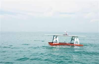
The picture shows the respondents of the Marine Meteorological Observer -3(MWO-3) semi-submersible solar meteorological exploration unmanned boat.
When encountering a strong typhoon, everyone is afraid to avoid it. But to obtain observation data, it is necessary to get close to the typhoon. Recently, the semi-submersible solar-powered meteorological exploration unmanned boat MWO-3, which was developed by China, successfully passed through the No.3 typhoon "Senlake" center this year, and obtained high-time resolution ocean surface meteorological and ocean element data during the development of the typhoon. According to reports, this is also the first time in the world to use solar unmanned boats to actively detect typhoon centers.
Some people may ask: We have launched so many meteorological satellites and there are many weather radars on the ground. Why do we use unmanned boats to detect typhoons? What are the superior performances of this unmanned boat? What data did the unmanned boat collect when it passed through the typhoon center in the storm? To this end, the reporter interviewed relevant experts and explained these issues one by one.
Seeing clearly inside the typhoon can greatly improve the observation accuracy.
It is understood that weather radar on land or island can detect typhoon precipitation and wind field within 200 kilometers around, which can play a very good role in monitoring typhoon activities in coastal areas. However, the radar can’t detect typhoons far away from the sea, and it can’t measure some factors that fully reflect the characteristics of typhoons, such as central air pressure, maximum wind speed and sea surface water temperature at the typhoon. In order to improve the fine level of typhoon forecast, it is necessary to accurately analyze the location and intensity of typhoons, and meteorological observers need to send "sentries" to monitor them further.
Compared with radar, satellites "stand high" and "see widely", and accordingly the monitoring range is larger. At present, satellite cloud images can help meteorological observers to see all typhoons and tropical storms, and then locate and determine their intensity. But at the same time, it is precisely because the observation position of the satellite is too high that the clarity of the observation results is sometimes difficult to guarantee, especially when the upper part of the typhoon is covered with thick cirrus clouds, the difficulty of locating and determining the typhoon intensity with satellite cloud images will greatly increase. If the center position of the typhoon cannot be accurately known, the meteorological observation numerical model can not accurately describe the vortex structure of the typhoon, and it will be difficult for observers to accurately track and predict the changes of the typhoon path and intensity, which will lead to a large forecast error.
"As a remote sensing technology, satellite observation can’t directly measure the precise parameters needed by our meteorological forecast and research, such as the pressure, temperature and airflow distribution inside the typhoon." Chen Hongbin, the chief scientist of the unmanned boat project and a researcher in lasg, told the Science and Technology Daily reporter.
The typhoon center pressure directly determines the typhoon intensity and maximum wind speed. Generally speaking, the lower the typhoon center pressure, the greater the pressure gradient within the typhoon range, and the more violent the wind. If we can get the wind, temperature field and humidity field in the typhoon, the accuracy of numerical prediction can be greatly improved. Therefore, it is very important to directly detect the sea surface pressure, wind field and other factors in the typhoon center for accurate typhoon forecast and early warning.
At present, some typhoon monitoring and forecasting institutions use manned and unmanned aircraft to fly over some parts of the typhoon and drop meteorological radiosondes with parachutes, and the measured temperature, pressure, humidity, wind speed and wind direction profile data have significantly improved the accuracy of typhoon path forecasting.
Experts told reporters that the study of typhoon evolution law and the improvement of numerical prediction accuracy require three-dimensional comprehensive detection of satellite remote sensing, shore-based radar, aircraft and sea surface monitoring devices. In the past, buoys were used to monitor typhoons on the sea surface, but now the addition of unmanned boats has provided greater help for typhoon monitoring. In this sea observation experiment, MWO-3 provided the China Meteorological Bureau with real-time observation data with a time resolution of up to 1 minute, and monitored the detailed change process of various elements of the sea surface when the typhoon transited. In the process of navigation observation, unmanned boat can maneuver and get real-time observation data of optimal position, which has unique advantages compared with traditional ocean buoy observation.
Special structural design creates a tumbler in the storm.
According to experts, if you want to stand the test of strong winds and waves in a typhoon, the unmanned boat should follow the waves better, or have stronger self-righting ability, so as not to "capsize" in the wind and waves.
MWO series semi-submersible solar meteorological exploration unmanned boat adopts catamaran to ensure stability, that is, connecting two identical buoys under the deck can provide greater buoyancy on the water surface. In addition, this design also gives the unmanned boat a semi-submersible function, that is, when the wind and waves are high, the unmanned boat can automatically or remotely control the water intake of the buoy, so that the whole boat body and bracket part sink into the water. As the center of gravity drops, the stability of the whole system is obviously enhanced, and it is difficult to overturn. In addition, although the hull is submerged, the weather sensor can float on the water surface and still work normally, and the Beidou satellite antenna on the sensor can also receive instructions and send data. This functional design is a highlight of MWO series semi-submersible solar meteorological exploration unmanned boat.
At the beginning of August, when the No.3 typhoon "Senlake" struck this year, MWO-3 showed its good maneuverability, strong resistance to wind and waves, automatic detection and real-time data transmission, and its superior detection ability was verified.
In addition, another major feature of MWO series semi-submersible solar meteorological exploration unmanned boats is the use of solar energy as an important power source. Using solar energy, on the one hand, it is clean and pollution-free, on the other hand, it can ensure that unmanned boats can sail for a long time. "Our unmanned boat design requirement is to ensure the observation and operation of the sea in the first half of the year. Especially in rainy weather, it is still necessary to ensure that meteorological detection and positioning data can be continuously transmitted back to the ground central station. " Chen Hongbin said.
Before the typhoon detection of the unmanned boat, the researchers will conduct a comprehensive test to ensure the reliability of the performance of the unmanned boat as much as possible, especially the waterproofing of the internal and external pipelines and the active obstacle avoidance ability of the unmanned boat. Before this typhoon detection, two unmanned boats were continuously tested and operated in the fishing port of Tanmen Center, qionghai city, Hainan Province for nearly one month, and then officially set out to sea on July 22nd to participate in the "Haiyan Plan" test organized by the Meteorological Exploration Center of China Meteorological Bureau, and made continuous navigation observation on the ocean surface about 120km east of Lingshui Li Autonomous County, Hainan Province.
On August 1st, the researchers planned the navigation route according to the satellite cloud image analysis, approached the typhoon center actively, and observed the rapid evolution of the No.3 typhoon "Senlake" from tropical depression to typhoon, which provided typhoon forecasters with on-the-spot observation data of the typhoon center in time.
Establishing a comprehensive observation network at sea by various observation means
According to reports, MWO-3 is equipped with automatic weather stations, solar radiation meters, sea surface water temperature and salinity sensors, wave meters and other observation devices. The available data include sea surface pressure, temperature, humidity, wind speed and direction, solar radiation, sea surface water temperature and salinity, wave parameters, etc., and can use the communication function of China’s Beidou satellite to send back a set of data every minute.
The observation data obtained by MWO-3 in this experiment were immediately sent to the Typhoon and Marine Meteorological Forecasting Center of the Central Meteorological Observatory, which played an important role in typhoon forecasting and early warning. "At that time, there were no other observation data nearby. The real-time data of MWO-3 was very precious and close to the low-pressure center, which was very beneficial for us to determine the location of the low-pressure center." Qian Chuanhai, director of the Typhoon and Marine Meteorological Forecasting Center of the Central Meteorological Observatory, commented.
In addition, the researchers also shared the data obtained through the typhoon with relevant research units to carry out in-depth quality control. For example, the observed humidity data under strong wind waves and rainy conditions will be further applied to numerical simulation and verification of some satellite remote sensing products after passing the reliability verification.
The reporter learned that MWO series semi-submersible solar meteorological detection unmanned boats can also be used to monitor the weather such as strong winds and fog at sea. After loading other sensors or equipment, they can also be used to collect data needed by other oceanographic research. For example, after loading carbon dioxide sensors, the carbon dioxide content in seawater can be measured, thus helping researchers understand the quality of seawater.
The researchers said that the biggest advantage of unmanned boats is their navigation maneuverability. The unmanned boat has super strong wind and wave resistance, which enables it to obtain real-time data of typhoon sea surface pressure, temperature, wind speed and direction, sea surface temperature and salinity and wave height in harsh environment, which provides very valuable information for typhoon numerical prediction and subsequent mechanism research.
"Through the two-week long-endurance observation test and the experience of crossing the typhoon, we have more confidence in the advanced and practical nature of the MWO series semi-submersible solar meteorological detection unmanned boat. However, for meteorological and environmental monitoring in the vast ocean, it is not enough to send two or three unmanned boats. " Chen Hongbin said that in the future, it is expected to use various observation methods such as unmanned boats, buoys and sea surface wave piercer to make comprehensive observation at sea, so as to enter the operational practical stage as soon as possible, provide more and better information for marine meteorology and environmental forecasting, and better serve maritime safety and resource utilization.